Showing posts with label glacier. Show all posts

Thursday, 9 December 2010

Aoraki (Mount Cook)

Getting a free map and driving instructions at the local tourist information centre, we left Twizel heading for nearby Aoraki (Mount Cook) in the national park carrying the same name.

Aoraki / Mount Cook


Aoraki is the tallest mountain in New Zealand. It's summit currently lies at 3754 metres above sea level. Currently? Yes the mountain, as part of the Southern Alps, is still growing.


So why the fuss with two names for the same mountain? As you probably already guessed Aoraki is the Maori name for the giant, while Pakeha (non-Maori Kiwis) named the mountain after their hero Captain Cook.
Traditionally the Maori name was supposed to mean: "Cloud Piercer"  judging from the word-meaning parts in Aoraki. A fitting and romantic name. However, closer to the truth is that the impressive mountain was named after Maori hero and legendary figure Aorangi (Maori spelling of Aoraki). After a Maori legend the South Island (Te Waka o Aoraki or Aoraki's Canoe) was the Canoe of Aoraki from which he pulled up a giant whale. Centuries later in the 19th century European explorers renamed the mountain to Mount Cook, giving it an English name.
After treaties between Maori and Pakeha the New Zealand government renamed the mountain again to: Aoraki / Mount Cook to account for the preceding traditional Maori name.
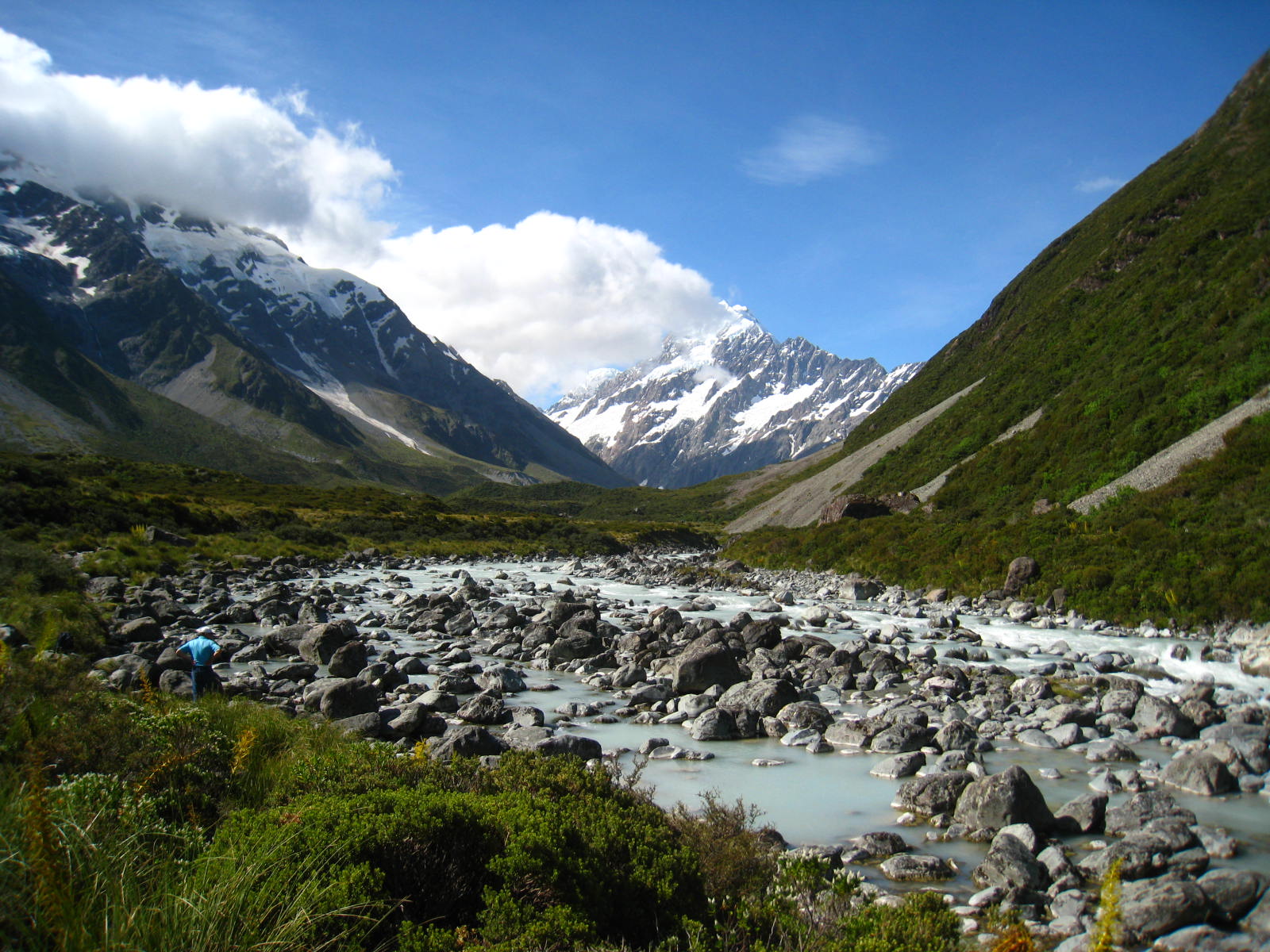

The mountain lies in the Aoraki / Mount Cook national park. Legally the area belongs to the Ngāi Tahu tribe. To present the government still needs to the return the land, however. Also the tribe agreed to officially hand over the land as a gift to the people in the form of a sacred national park, like it was done with Tongariru.


Romanticised or not the name "Cloud Piercer" fits the mountain perfectly. It towers even over the other tall giants of the Southern Alps that surround it and always has a cloud in the middle, which it actually pierces through, as the cloud is around the mountain.


Following the driving instructions we hit a nearby DOC camp with parking ground, from where we started walking the official track leading to the feet of Aoraki.


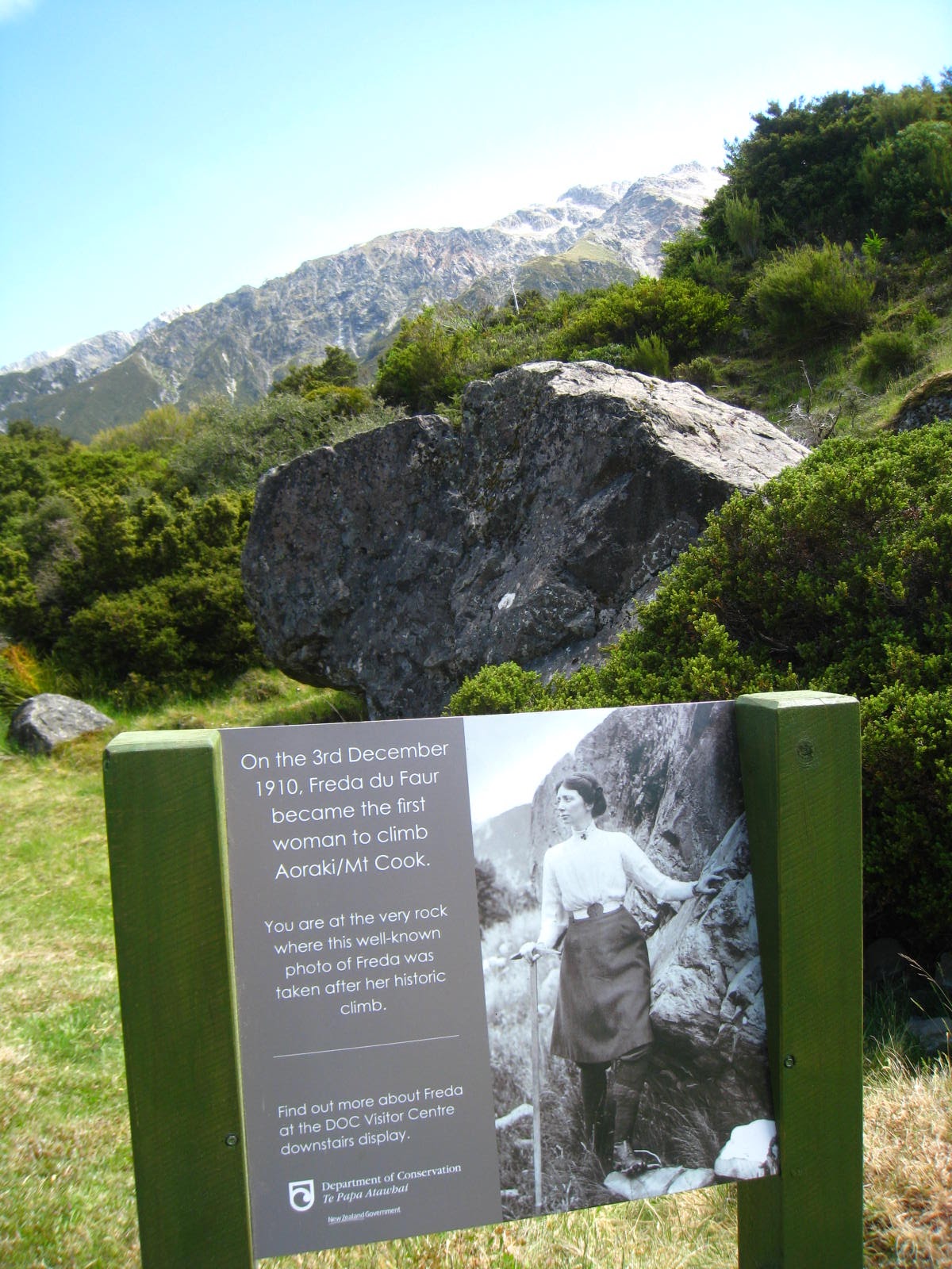
Right at the beginning of the track we found a stone with a little plaque commemorating the first woman to climb Aoraki all by herself. An impressive deed at the time considering the patriarchal society at the time. Bilge Rat took the woman as inspiration to achieve similar impressive deeds on her own, and we made a commemoration picture of her in advance :D.


The track leads through Hooker Valley. Yes that's the name of the valley. Probably some Pakeha explores carried that name. Anyway, the valley is really beautiful and diverse making the hike extraordinarily enjoyable.


At the end you don't only stand by the feet of New Zealand's tallest giant, you also see and feel the roaring glacier fighting its way down the mountain into a fast glacier torrent carrying the melted ice dutifully away. The minerals carved out by the glacier further give the water a milky white colour. The time when we were there was the middle of summer, so the glacier melted down and was covered by a lot of gravel (see pictures below).

milky white glacier torrent
Hooker Glacier
Aoraki, truly a remarkable mountain.

Thursday, 2 December 2010

Rob Roy Valley

Routeburn Track

At this point we were thinking about daring our next Great Walk: the Routeburn Track. The Routeburn Track is a fantastical walking track connecting Queenstown (over Glenorchy) with Te Anau and Milford Sound (over the Divide). Believe it or not up to this date, the walking track is the only direct connection between those places. The only other option is to take the over 300 km detour around the Southern Alps.

However exactly this fact in the end made us forfeit any plans to walk the track. Because of the missing car or train connection, the big problem is to get back to your car after completing the track. You basically have four options:
  1. Walk the whole track back.
  2. Hitchhike the whole distance of 333 km back. 
  3. Get someone to pick you up.
  4. There is a service, where someone will actually drive your car all the 333 km.
1 was too much effort and time. We didn't think of 2 at first, but hitchhiking is always a matter of luck, especially for that distance. 3 We knew no people around here. And the service 4 is damn expensive.

So in the end we decided not to walk the Routburn Track, as amazing as it would have been.


Rob Roy Valley


Our travel guide book said: "If you can't do the Routeburn Track go for the one day Rob Roy Valley Track. It is also through the Mt. Aspiring National Park and you get to see a lot of amazing things, including lots of native birds like Kea, mountains and valleys and an amazing glacier. Well if that doesn't sound like a good alternative, I don't know what does.


the sound Keas make really sounds like "keee-ah"
Thus of we went. Of course all our little trips where according to a great master plan (have you ever doubted that?). Therefore it is not surprising that Rob Roy Valley is only a little further down the road that passes South Rivendell. So conveniently we combined both and after visiting Rivendell went further to Rob Roy Valley.


The valley was astounding. It was really beautiful, especially in the later afternoon sunlight (and later the evening light, when we went back). All the lakes and rivers shimmered in the reflection of the sunlight. The meadow was in a fresh green and in the back you could see the amazing stature of the snow covered Alps.


Although it is called Rob Roy Valley Track, you actually continuously climb upwards. First through thick forests and at the end over barren grey dust and rocks (carved from the glacier). All the while along a ravenous torrent that comes down from the glacier into the valley. The trip is very strenuous but totally worth the effort. The view at the end and the glacier is amazing. We met some hikers on the way that told us they actually saw and heard part of the glacier break off and fall down the mountain. Wow.


ravenous torrent
When we reached the end of the path, we didn't know we reached the end of the path. We suspected it, because of the missing markers. However even after one hour of further walking (to the later suspected end of the track) there was still a trodden track on the ground that could be followed. It just got more and more steep and more and more difficult to follow. So that after 1 hour bilge rat made a halt. I, however, wanted to looked over one more mountain top and carried on for another 30 minutes. In the end the track got so slippery that bilge rat feared for my life. Little did she know, that in my previous life I was a mountain antelope, thus I had little problem, got my additional kick and then went back with her to enjoy the glacier and the valley with the light of a setting sun...

Rob Roy Glacier
setting sun

Wednesday, 1 December 2010

Franz-Josef Glacier

After resting with the spirits of old gold miners, we move on southwards. Our next stop was the little mountain town Franz-Josef. The town is named after the nearby glacier named Franz-Josef Glacier after the great Austrian emperor by the German explorer Julius von Haast in 1865.


Except for a supermarket, the i-Site and the glacier, there is not much to see or do in Franz-Josef. At the information centre you can get leaflets describing a couple of different walking tracks leading you to the foot of the glacier. If you want to ascent further unto the actual glacier ice, you'll have to book a guided tour, as it is too dangerous to proceed without proper experience and equipment.


We went for the easiest walking trail, because it takes you closest to the glacier. It was the first time for bilge rat to set eyes on a real glacier. It was none less spectacular for me. The last glacier I has seen in the Austrian alps as a little lad and even then it was a high mountain glacier seen from a distance. Franz-Josef on the other hand pushes down the mountain until he reaches the actual surface level. So you can get very close without climbing any mountains.


At the foot of the glacier you can see and hear a raging torrent of melted glacier ice, steadily supplied by new glacier ice. You can also tiny human specs actually walking on the glacier ice. Bilge Rat and I passed on the guided tour this time. If you want to do one, you can get information about the tours and do the booking at the information centre.


Oh I forgot one of the most amazing things about our little visit of the glacier. Well it's summer right? Sunshine and nice t-shirt weather and everything, right? Well but there we were, touching ice in the middle of summer. And the glacier ice survives the summer too.


Quite cool!
Scallywag